
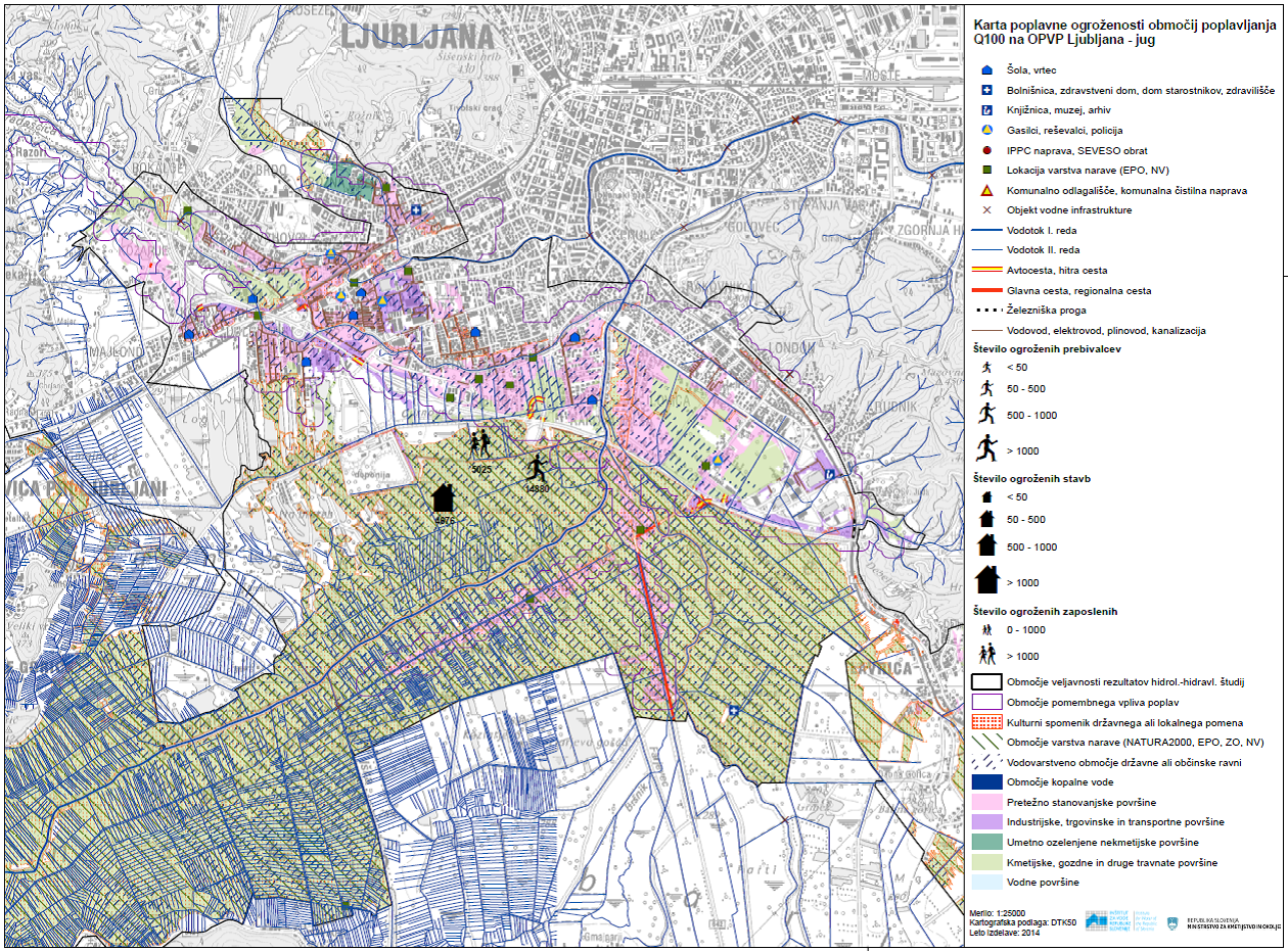
The scope of the task is set out in the Framework Programme for the Implementation of the Directive on the Assessment and Management of Flood Risks for the period 2009–2015 (Ministry of the Environment and Spatial Planning of the Republic of Slovenia, May 2009). The legal framework for the task is set out in Article 6(5) of Directive 2007/60/EC (OJ EU, No L 288), which has been transposed into Slovenian law by Articles 11, 12 and 13 of the Regulation on the content and method of preparation of a detailed flood risk reduction plan (Official Gazette of the Republic of Slovenia, No. 7/2010), adopted pursuant to Article 60a of the Act Amending the Water Act (Official Gazette of the Republic of Slovenia, No. 57/2008). The primary purpose of the task is to provide a technical basis for setting objectives and measures within the framework of flood risk reduction planning in 2014 and 2015 for 61 areas of significant flood impact.
Articles 11, 12 and 13 of the Regulation on the National Flood Risk Assessment (NZPO) set out the method, content and timetable for the preparation of flood hazard and risk maps. With regard to the method of preparing the maps, it is stipulated that the Ministry must ensure that the maps are prepared at the most appropriate scale for areas of significant flood risk, in accordance with the regulation on the methodology for determining flood areas at the level of river basin districts under the Water Act. With regard to the content of the maps, the Regulation stipulates that flood risk maps must show the potential adverse consequences associated with three types of flooding (floods with low, medium and high probability of occurrence – in the context of the methodological guidelines, these are floods with return periods of 10, 100 and 500 years), expressed in terms of:
- the approximate number of people who may be affected by the flood,
- the types of economic activities in the area that may be affected by flooding,
- potentially significant sources of pollution which, in the event of flooding, may cause accidental pollution, and areas with specific requirements in accordance with the regulation governing the detailed content of the water management plan under the Water Act, which may be affected by flooding, and
- other relevant information, such as the identification of areas where flooding may occur with high sediment or debris loads, information on other major sources of pollution, and information on cultural heritage.
Maps of the damage potential of Q10, Q100 and Q500 flood areas, commonly referred to as ‘flood hazard maps’, can serve, at the national planning level, as a tool for setting general risk reduction targets for the entire area of significant flood impact. It is important to emphasise that these maps do not define a combined hazard class for the selected area (different hazard classes, different types and quantities of people at risk), which is at least as important for planning measures as, for example, the combined hazard level is for the conditions and restrictions on the siting of new buildings (based on a combination of different return periods and depth ranges). Indeed, knowledge of the combined hazard class in a selected area of the pNRP OPN can provide the technical basis for implementing a non-construction measure to amend the detailed land-use designation.
A total of 132 flood hazard maps have been updated or newly produced for 44 areas of significant flood impact (out of a total of 61), for which more or less complete data exist on flood extents with return periods of 10, 100 and 500 years (Figure 4-1). Statistics on the population at risk in flood-prone areas have been compiled and are used when completing EC reporting forms. The current status of spatial coverage of areas significantly affected by flooding has been determined using data on flood extent for 10, 100 and 500-year return periods, which forms the basis for the preparation of the 17 missing flood risk maps.
In the second cycle of implementation of the Floods Directive and when preparing a new preliminary flood risk assessment, it will be necessary to provide for improvements to the vulnerability and risk criteria set out in the methodological guidelines and to clearly define the purpose and use of risk maps and risk classes in the context of spatial planning and the planning of flood defence measures. To ensure the correct application of the flood risk maps produced as part of reporting to the Commission on compliance with the provisions of Article 6 of the Floods Directive, the competent authority must amend the subordinate legislation (the Methodological Regulations and the Regulation on the National Flood Protection Programme) which define flood hazard maps differently.
Link to additional content:
Preparation of flood hazard maps for 27 areas of significant flood impact in the Republic of Slovenia. Annual report on work carried out under task I/2/2, task leader: Blažo Đurović. Water Research Institute of the Republic of Slovenia, December 2013. Client: Ministry of the Environment and Spatial Planning (MOP), IzVRS work programme for 2013; Available at: http://evode.arso.gov.si/direktive/FD_tabela.htm
Preparation of flood hazard maps for 28 areas of significant flood impact in the Republic of Slovenia. Annual report on work carried out under Task I/2/2, project leader: Blažo Đurović. Water Institute of the Republic of Slovenia, December 2014. Commissioned by: Ministry of the Environment and Spatial Planning (MOP), IzVRS work programme for 2014; Available at: http://evode.arso.gov.si/direktive/FD_tabela.htm
Project collaborators:
MAZI Tina, Dr ZUPAN VRENKO Dunja
Related content:
- Classification of flood-prone areas and identification of areas significantly affected by flooding in Slovenia. Annual report on work carried out under task I/2/1.1, task leader: Blažo Đurović. Water Research Institute of the Republic of Slovenia, May 2012. Client: Ministry of the Environment and Spatial Planning (MOP), IzVRS work programme for 2012; Available at: http://evode.arso.gov.si/direktive/FD_tabela.htm
- Updating of the integrated flood hazard map and the integrated flood hazard class map for publication in the Environmental Atlas (60 new HH studies) and production of the integrated depth map at Q100. Annual report on work on task I/2/6, task leader: Mladen Ajdič. Water Research Institute of the Republic of Slovenia, December 2014. Commissioned by: Ministry of the Environment and Spatial Planning (MOP), IzVRS work programme for 2014 (the project has been ongoing since 2012); Available at: http://evode.arso.gov.si/direktive/FD_tabela.htm
- Preparation of the economic aspects of flood risk reduction plans. Annual report on work carried out under task I/2/3, project leader: Špela Petelin. Water Research Institute of the Republic of Slovenia, December 2014. Commissioned by: Ministry of the Environment and Spatial Planning (MOP), Water Institute of the Republic of Slovenia (IzVRS) work programme for 2014 (the task has been ongoing since 2013); Available at: http://evode.arso.gov.si/direktive/FD_tabela.htm
Keywords
About the project
REPUBLIC OF SLOVENIA MINISTRY OF THE ENVIRONMENT AND SPATIAL PLANNING
Blažo Đurović
#Dr Dunja Zupan Vrenko #Tina Mazi
OTHER DOMESTIC PROJECTS
