
Update of the 2007 flood warning map published on the Environmental Atlas
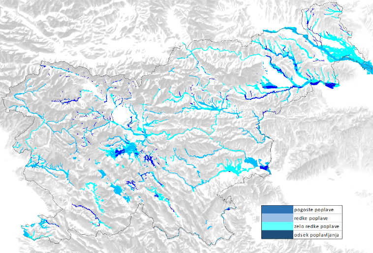
The flood hazard map (OPKp) and its role are defined in the Rules on the methodology for determining areas at risk of flooding and associated erosion of inland waters and the sea, and on the method of classifying land into risk categories, Official Gazette of the Republic of Slovenia, No. 60/2007.
One of the main purposes of the OPKp is to consolidate available data on the extent of flooding. The content is updated and supplemented in line with available data and financial resources, and the presentation is suitable for maps at a scale of 1:50,000 and less precise.
The aim of publishing this layer is to alert spatial planners and the general public to the risk of flooding.
The contents of OPKp2014 are:
- flood map (very rare floods, rare floods and frequent floods)
- flood map (direction of flood flow)
- flood map (sections of watercourses prone to flooding)
- functional floodplains
- flood events
Sources:
The data used to update the OPKp are drawn from various sources, with varying levels of accuracy in their production and (cartographic, digital) representation, as well as differing time periods. The graphics are based on:
- OPKp2007;
- OPKp2012 February;
- OPKp2012 November;
- flood events recorded in the recent and distant past (flood lines determined on the basis of actual flood events);
- models (flood lines determined on the basis of hydrology and hydraulics);
- other (various sources, e.g. Ujma magazine, Geografski zbornik…)
The flood areas shown do not cover all flood-prone areas, but only those for which data were available and which could be integrated into the OPKp layers within the time available.
Therefore, PLEASE NOTE: Where a flood area is NOT marked, this does NOT mean that there is NO risk of flooding in that area.
Occasional changes to the layer are possible insofar as obvious errors or additional information are identified and taken into account, leading to the definition of additional (revised) flood areas or to a change in the accuracy of the extent of already shown flooded areas and water levels.
The accuracy of the display varies considerably from one data source to another, but adheres to the accuracy standard for maps at a scale of at least 1:50,000. The sources vary in terms of production accuracy and (cartographic, digital) recording, as well as in terms of temporal distance, and cover flood events recorded in the recent and distant past, results of hydraulic models, publications, etc.
RELIABILITY RATING: 1…lowest, 10…highest reliability of the representation, covering both the reliability of the content and the accuracy of data capture.
The reliability rating is an expert assessment:
1–4 based on knowledge of the area, individual flood data of varying quality, and data from a long time ago;
5–6 better knowledge of the area, individual flood data of better quality, more recent data, hydrological data, simplified hydraulic calculations;
7–8 better knowledge of the area, higher-quality flood data – recorded events, more recent data, better hydrological data, hydraulic calculations based on older data;
9–10 good knowledge of the area, good flood data – recorded and analysed events, more recent data, good hydrological data, recent hydraulic calculations using modern tools.
Content currently available on the Environmental Atlas (OPKp 2007):
- flood warning map (frequent)
- flood warning map (rare)
- flood warning map (very rare)
- flood warning map (direction)
- flood line (note: these are sections of watercourses that flood)
- flood events
have been replaced in the OPKp 2014 by the following content (layers):
- frequent floods
- rare floods
- very rare floods
- direction of flood flow
- flooding section
- functional floodplains
- flood events (defined by date)
The data layer has been updated and submitted to the Ministry of the Environment and Spatial Planning (MOP), which is due to forward it to the Agency for the Environment and Spatial Planning (ARSO) for publication on the Environmental Atlas following approval.
Keywords
About the project
Project
value:
8,200 EUR
REPUBLIC OF SLOVENIA MINISTRY OF THE ENVIRONMENT AND SPATIAL PLANNING
Darko Anzeljc
#Tina Mazi
Project library
Photo gallery