
Directive 2007/60/EC of the European Parliament and of the Council of 23 October 2007 on the assessment and management of flood risks (hereinafter ‘the Directive’) is intended to significantly improve the situation in this area by introducing the principle of preventive action in flood risk management, replacing the previous concept of ensuring a selected level of safety. It is aimed at preventing development in existing hazard areas, protecting existing flood-prone areas and ensuring preparedness for flood events. The Directive requires a reduction in vulnerability (as opposed to the previous model of ensuring safety), primarily through non-structural measures such as information and awareness-raising, spatial planning, early warning systems, protection and rescue services, and insurance, as well as engineering measures and construction standards in flood-prone areas.
The aim of this study is to examine the method for determining the level of vulnerability (potential for damage) in a flood-prone area, for use in determining the level of flood risk. The Directive states that, in order to reduce the adverse effects of floods, flood risk management plans must be put in place. These plans must focus on prevention, protection and preparedness; they must take into account the preservation of existing floodplains and include measures to prevent and minimise damage to human health, the environment, cultural heritage and economic activity. The Directive further stipulates that flood hazard maps and flood risk maps must be drawn up by 22 December 2013 for areas previously identified as being at significant risk of flooding. Under Slovenian legislation, flood hazard maps and flood risk maps must be drawn up in accordance with the Regulations, which also sets out the method for preparing these maps and defines the criteria for classifying flood risk into flood risk classes (high, medium and low flood risk). This subordinate legislation therefore ensures the use of a uniform methodology for the preparation of flood hazard and risk maps.
A vulnerability analysis is prescribed in the Regulations (Article 14) and is carried out for the purpose of assessing the vulnerability of individual vulnerability elements or groups of vulnerability elements (population size, type of economic activity, sources of pollution and areas with specific requirements, cultural heritage). However, where necessary for the planning of measures or other relevant activities relating to flood risk, the vulnerability analysis may also include a more detailed analysis of land use and an assessment of potential damage (indirect and direct damage).
On the basis of the vulnerability analysis, hazard elements are classified into four vulnerability classes (high, medium, low and very low vulnerability). The vulnerability class is determined on the basis of criteria that classify risk elements into groups according to the magnitude and significance of potential damage. In accordance with the Regulations, the flood risk class is determined on the basis of the criteria for classifying flood risk (Annex V) and depends on the hazard class and the vulnerability class of the risk elements.
In this study, we have slightly amended or supplemented the criteria for determining vulnerability classes in line with the availability of data, which is in accordance with the second paragraph of Article 14 of the Regulations. We have supplemented the criteria because we consider that they reflect a more realistic assessment of the degree of vulnerability of the damage potential. To describe the damage potential, we used data on hazard elements that were employed in the previous flood risk assessment (IzVRS, 2012).
The scope of the study therefore comprises the development of a procedure and a description of the method for determining the level of vulnerability for the purpose of establishing the level of flood risk in areas of significant flood impact.
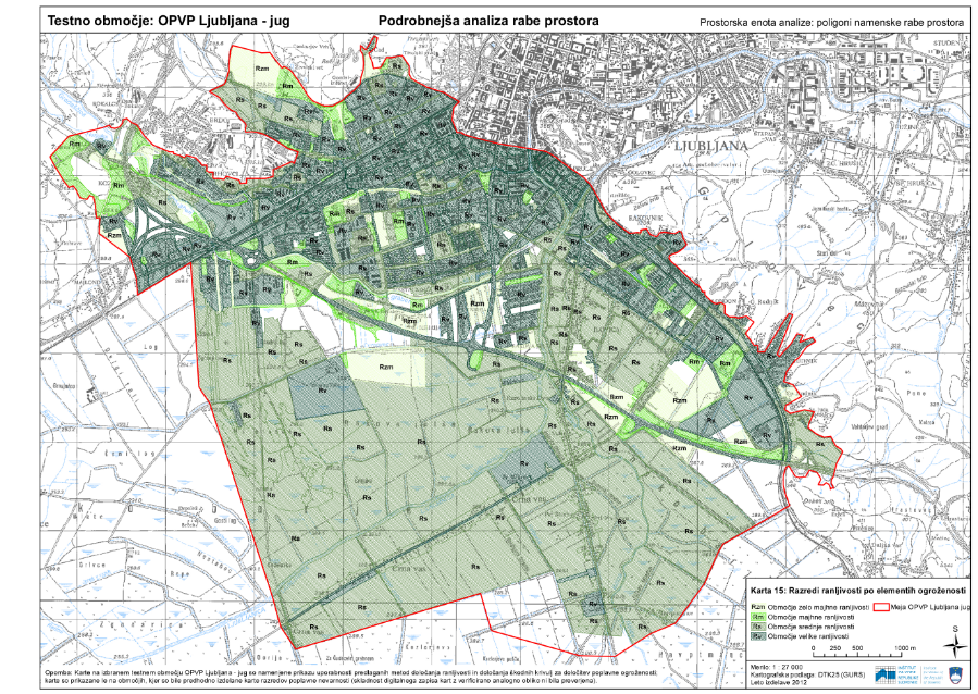
In this study, the method for determining vulnerability and the approach to presenting flood risk were examined in the Ljubljana-South test area of significant flood impact (OPVP), in accordance with the Regulations. Using a specific case study, the procedure for determining vulnerability was tested and described, and the findings were presented as guidance for further work relating to flood risk management.
Keywords
About the project
REPUBLIC OF SLOVENIA MINISTRY OF THE ENVIRONMENT AND SPATIAL PLANNING
Tina Mazi
#Blažo Đurović #Darko Anzeljc #Maja Kregar #Saša Bobnar #Špela Petelin
PROJECT BROCHURE
Photo gallery