
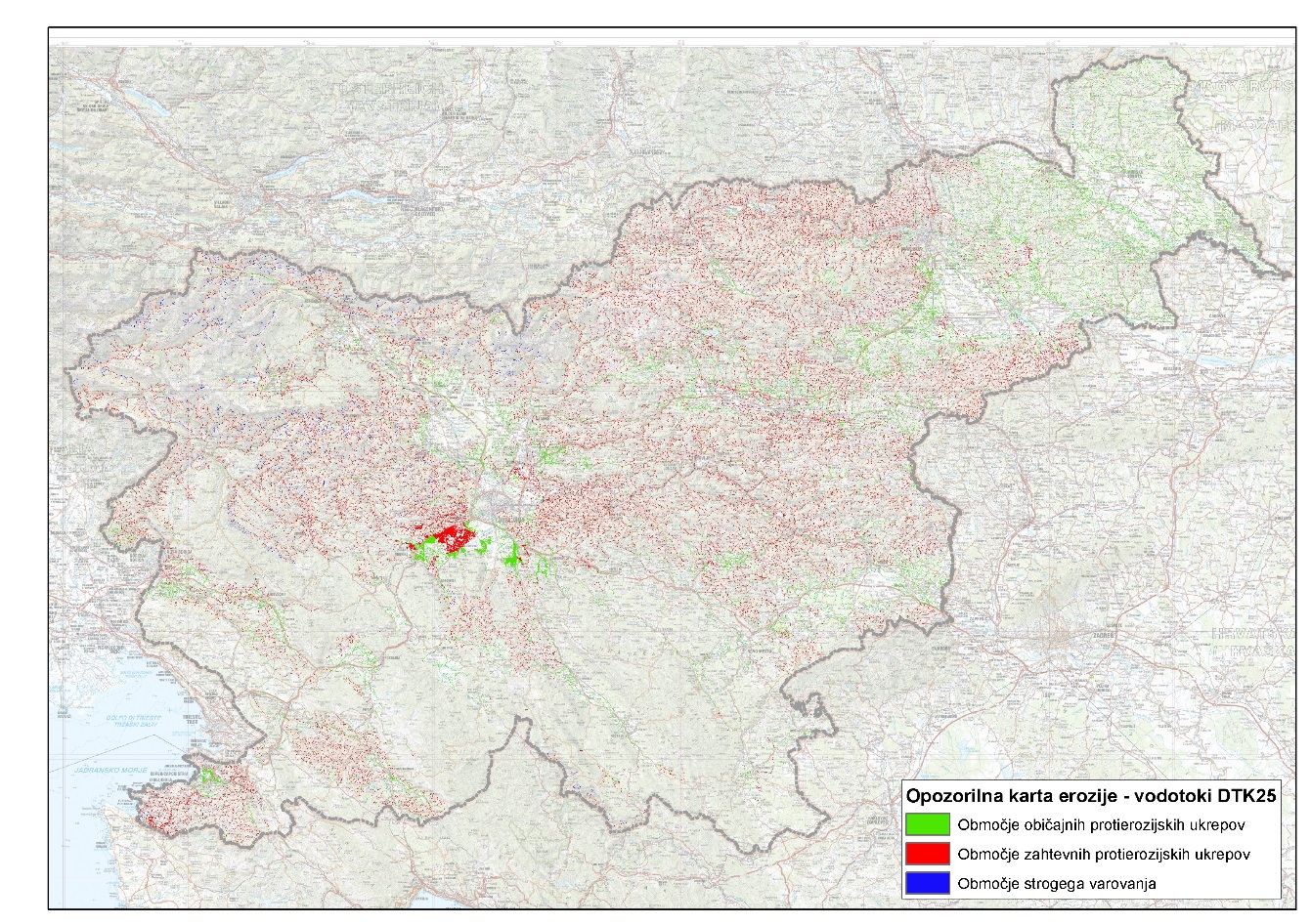
The Methodological Guidelines on Flood and Erosion Areas stipulate that the assessment of flood and erosion risk is shown on a flood and erosion hazard map, and that, on the basis of this map and the criteria set out in the regulations, the most significant risk and vulnerability areas are identified, for which more detailed analyses are then carried out. The project brief was drawn up with the aim of providing a technical basis for the implementation of Article 83 of the Water Act, which, amongst other things, provides for the identification of areas at risk from erosion of inland waters and the sea. The erosion warning map is defined in greater detail by the methodological regulations (Official Gazette of the Republic of Slovenia, No. 60/2007), which stipulates that the warning map shall be drawn up for the first time on the basis of an analysis of historical and archival data on erosion events and on the basis of previously conducted studies, research, analyses and other data. The map is updated at least every six years. The main objective of the project was to produce a draft erosion warning map at a scale of less than 1:50,000000 for the entire national territory, which can then be subject to expert review and officially published in the Environmental Atlas.
The results of the work carried out on the project between 2008 and 2012 provide a sound technical basis for the production of a national-level erosion hazard map. The basic project brief was drawn up in mid-2008 and the work was carried out in three phases between 2008 and 2012. Guidelines are also provided for future work on the technical basis for producing the erosion warning map. The content of the project represents a significant contribution to the implementation of the provisions of the methodological guidelines, the Regulation on Conditions and Restrictions, the Regulation on the content and method of preparing the National Erosion Hazard Map (NZPO), and the Rules on the content of applications for project conditions and water consent. The project comprised the following sections:
- Review and analysis of the current situation regarding the description of erosion hazards in Slovenia.
- Compilation of a list of existing data sources and acquisition of available data records.
- Comparison of methodologies for the collection, processing, presentation and use of erosion data with methodological approaches in other countries, particularly neighbouring Alpine countries.
- Drafting a proposal for the content, structure and method of presenting erosion data on a warning map, taking into account actual and potential depth and lateral erosion of inland waters and marine erosion, the potential for landslides and soil slippage in the wider hinterland of watercourses, and the locations of temporarily deposited erosion debris in gullies, on slopes and scree slopes at the foot of mountain faces, on torrential debris cones, etc.
- Preparation of a draft erosion warning map in accordance with the requirements set out in Article 8 of the Regulations.
- Formulation of proposals for further work on the preparation of the first official erosion hazard map.
Results of Phases I and II:
- an overview of the current situation regarding the management of erosion risks in Slovenia
- 33 data sources relating to erosion issues collected and analysed
- proposal for the content and draft of the warning map: “EROSION: protected areas – measures and restrictions”
- analysis of the methodological approach and results of the production of erosion maps in accordance with the 2007 Regulations (source 0033)
- analysis of various aspects of presenting erosion issues in relation to the 2007 Regulations (“flood-related erosion”) with regard to:
- level of detail (local, regional, national)
- actual : potential erosion
- surface : linear erosion
- torrential erosion (specific characteristics of torrential processes and phenomena)
- the role and importance of forested areas (protective and conservation forests, potential erosion areas)
- the importance of data on flood and erosion events
- the importance of data on water infrastructure
- delimitation and ‘interaction’ between flood, erosion, landslide-prone and landslide-affected areas
It was found that the entire territory of Slovenia is covered solely by data from three maps produced in 1999. These maps were proposed in 2001 as part of the water management content for Slovenia’s spatial plan. The data types cover surface and, to some extent, torrential erosion (eroded areas and erosion hotspots), landslide erosion (conditionally stable and unstable land), snow erosion (snow avalanche paths) and disruptive erosion (rockfalls). In fact, the data from these three maps were used in 20 processed sources, at least as a basis for further work, and directly incorporated (albeit usually modified and supplemented) in 14 of the processed sources. The data are therefore used in practice, either in a methodological sense or as a starting point for more detailed analysis. The included data on snow avalanches are of high quality, whilst the remaining data are not directly transferable to a more detailed level; rather, critical assessment is required on a case-by-case basis. Furthermore, in certain areas, the map is incomplete, generalised and does not cover the full scope of the erosion problem in Slovenia. Nevertheless, the map serves as a foundation that we can build upon, supplement and update in the coming years. Updating would take place either by generalising the results of more detailed mapping (at municipal level) on a smaller scale, or through an assessment of erosion risk at national level (analysing data on watercourses – lines – and catchment areas – torrential areas)
Results of Phase III:
The following data are taken into account when determining linear erosion:
- average annual rainfall
- slopes
- erosion coefficient Z along watersheds
However, the factors considered are certainly not sufficient for the correct ranking and indexing of watercourse channels in terms of the severity of erosion problems. From the perspective of the erosion warning map of Slovenia, all torrential river channels should be classified as areas requiring strict protection, including both erosion-active channels with advancing erosion processes, as well as erosion-active channels with foreseeable potential erosion processes, and relatively stable channels without noticeable tendencies towards deepening and sedimentation, sections with sediment stagnation, sediment accumulation and sections with torrential erosion in the channels (lateral erosion – erosion gullies), and torrential scour marks.
Linear erosion is categorised into three levels:
- Stage 3: warning areas requiring strict protection.
- Stage 2: warning areas where protective measures are to be implemented – more extensive protective measures;
- Stage 1: warning areas where protective measures are to be implemented – standard protective measures;
The developed method needs to be further refined, in particular through the use of appropriate data that will meet requirements for precision, accuracy and adequate spatial coverage. This particularly concerns data that would be available for the territory of Slovenia and which could be appropriately indexed:
- Precipitation intensity (48-hour rainfall)
- Runoff coefficient
- Data on the presence and condition of water management infrastructure (in particular the locations of key flood control and flood retention structures, and anti-erosion structures within the system)
- Data on past events related to watercourses
Link to additional content:
- Erosion warning map (2008–2012). Annual report on work carried out under task I/2/2.3, task leader: Blažo Đurović. Water Institute of the Republic of Slovenia, January 2013. Client: Ministry of the Environment and Spatial Planning, IzVRS work programme for 2008–2012.
- PUH (2008). Erosion warning map – Phase I. Final report on work carried out on the project task. Torrent Control Company, Ljubljana.
- PUH (2010). Erosion Warning Map – Phase II. Final report on work carried out under the project brief. Torrent Control Company, Ljubljana.
- PUH (2011). Erosion warning map – Phase III. Final report on the project. Torrent Control Company, Ljubljana.
Project collaborators:
ANZELJC Darko, Jože PAPEŽ, MA (Torrential Stream Management Company)
Related content:
- Flood warning map. Annual report on work on task I-2-3-1-1, task leader: Darko Anzeljc. Water Research Institute of the Republic of Slovenia, December 2007. Client: Ministry of the Environment and Spatial Planning (MOP), IzVRS work programme for 2007
- Revision and update of the Flood Warning Map. Annual report on work on task I/2/2.1, project leader: Darko Anzeljc. Water Institute of the Republic of Slovenia, November 2012. Commissioned by: Ministry of the Environment and Spatial Planning (MOP), IzVRS work programme for 2012; Available at: http://evode.arso.gov.si/direktive/FD_tabela.htm
- Preliminary assessment of flood risk. Annual report on work on task I/3/1, task leader: Darko Anzeljc. Water Research Institute of the Republic of Slovenia, December 2011. Commissioned by: Ministry of the Environment and Spatial Planning, IzVRS work programme for 2011
Keywords
About the project
REPUBLIC OF SLOVENIA MINISTRY OF THE ENVIRONMENT AND SPATIAL PLANNING
Blažo Đurović
#Darko Anzeljc #Jože Papež, MA
Project library
Photo gallery