
Preliminary Flood Risk Assessment
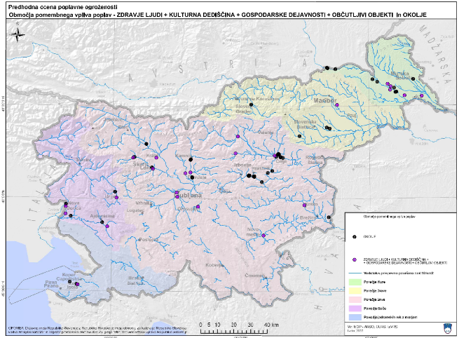
This document presents the content derived from the requirements of Directive 2007/60/EC. It sets out the sources of the data used, the methods employed and the results, taking into account the principles of transparency and homogeneity, for the purpose of identifying areas of potential flood risk and classifying flood risk areas by severity (at national level) according to the degree of risk. This tool is suitable for use in the decision-making process.
Purpose, content and objective
The primary purpose was to classify flood risk areas by significance (at national level) based on a methodological approach that takes into account data on hazard potential (type, extent, probability, intensity and duration of flood events) and damage potential (extent, value, vulnerability and exposure of people, the environment, cultural heritage and economic activities).
In addition to determining the magnitude of the hazard potential, it was also necessary to determine the magnitude of the damage potential in flood-prone areas and to classify it into magnitude classes using appropriate indicators. The indicators and classes are defined on the basis of available data on the location and number of residents living permanently or temporarily in Slovenia, on areas and facilities which, under environmental protection regulations, could give rise to large-scale environmental pollution, data on cultural heritage protected under regulations on the protection of cultural heritage; and data on areas significant for the conduct of economic and non-economic activities.
The Regulation on the content and method of preparing a detailed flood risk reduction plan (Official Gazette of the Republic of Slovenia, No. 7/2010) sets out the method of preparation in Article 7 and the content of the preliminary flood risk assessment in Article 8.
In Article 9, the Ministry identifies those areas where it determines that there is a possibility of a significant impact from flooding.
The aim of this study is therefore to assess the extent of potential flood damage in Slovenia using the most objective methods, criteria and standards possible. It makes sense to assess the damage potential of spatial elements across the entire national territory in order to ensure, as far as possible, the sustainability of the results of the risk analysis, as the flood-prone areas on the flood warning map are updated in accordance with Article 7(2) of the Rules on the Methodology for Determining Areas at risk from flooding and associated erosion of inland waters and the sea, and on the method of classifying land into risk categories (Official Gazette of the Republic of Slovenia, No. 60/2007).
Some of the topics covered in the report
DIRECTIVE 2007/60/EC (FLOOD DIRECTIVE)
- Water management and Directive 2007/60/EC
- Implementation of the Floods Directive in Slovenia
- Transposition of the provisions of the Floods Directive into Slovenian legislation
- Preparation of technical bases for decision-making
- Definition of water management objectives
METHODOLOGICAL APPROACH
RISK POTENTIAL
DAMAGE POTENTIAL
CLASSIFICATION OF FLOOD-PRONE AREAS ACCORDING TO THE LEVEL OF RISK
REQUIREMENTS OF ARTICLE 4 OF THE FLOOD DIRECTIVE
- description of past and major floods
REQUIREMENTS OF ARTICLE 5 OF THE FLOOD DIRECTIVE
- Proposal 1: Areas of significant flood impact (in accordance with water regulations)
- Proposal 2: Areas of significant flood impact (proposal by IzVRS)
- Proposal 3: Areas of significant flood impact (proposal by IzVRS)
Conclusion
An analysis of the damage caused by individual events shows that the proportion of total direct damage to water infrastructure has risen steadily since the 1990 event, when it stood at approximately 19 per cent, as shown: 25 per cent in 1998, 38 per cent in 2007, 72 per cent in 2009 and 62 per cent in 2010.
Furthermore, we can conclude that increased maintenance of water infrastructure would not only have reduced damage to the infrastructure itself, but would also have ensured that the infrastructure performed its function, thereby consequently reducing damage in other categories as well.
Based on the above finding and the identification of areas significantly affected by flooding, we propose, as a measure, an increase in investment maintenance, prioritising water infrastructure that affects areas significantly impacted by flooding.
Keywords
areas of significant flood impact,
About the project
REPUBLIC OF SLOVENIA MINISTRY OF THE ENVIRONMENT AND SPATIAL PLANNING
Darko Anzeljc
#Blažo Đurović #Katja Sovre
OTHER DOMESTIC REFERENCES
