
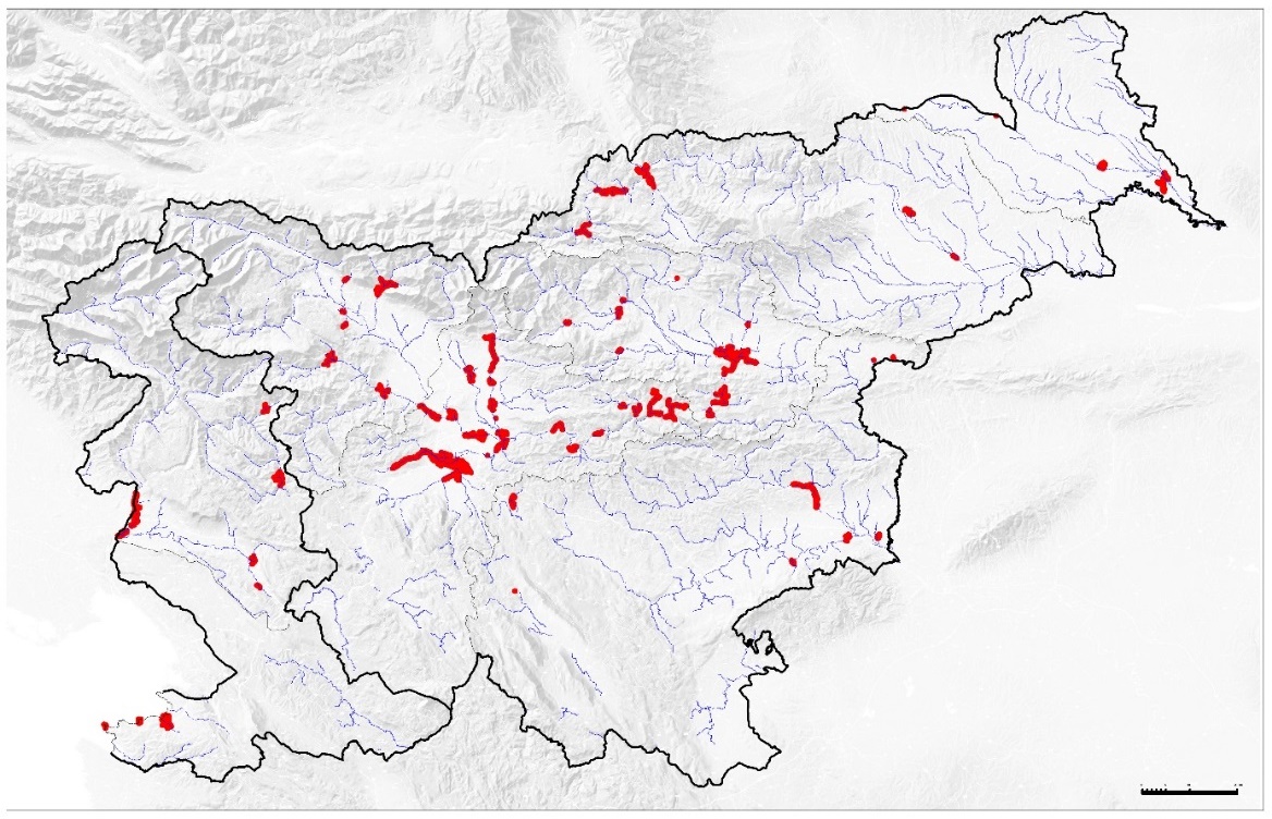
One of the key objectives of the preliminary flood risk assessment is to identify areas at significant risk of flooding at national level, for which more detailed hazard and risk maps, as well as risk reduction plans, are to be drawn up. As part of the preliminary assessment and analysis of future floods and their potential damaging consequences, a tool has been developed which improves the transparency of decision-making regarding the locations of flood-prone areas for which flood risk reduction plans must be drawn up as a matter of priority and funding secured for the implementation of the planned flood protection measures.
The concept of prioritising actual and potential flood-prone areas was applied in this process. Based on five basic maps classifying flood-prone areas and a sixth, combined map, and on the basis of the selected significance criterion, eight alternative proposals for areas of significant flood impact were drawn up. The proposal for public consultation was drawn up on the basis of a single criterion comprising the top 40 per cent of the combined risk index of the (K) map and the top 20 per cent of the combined index of the basic (O) maps classifying human health (ZL), the environment (OK), cultural heritage (KD), economic activities (GD) and sensitive facilities (OB). Following the conclusion of the public consultation and the consideration of 50 proposals, comments and initiatives, a final data layer was produced at a scale of 1:50,000, containing 61 areas of significant flood impact in the Republic of Slovenia and basic statistics on the population at risk in these areas.
Across the 61 areas of significant flood impact, which together cover 50 km², 130,000 residents, 23,000 buildings, 540 cultural monuments, 17,000 businesses, 600 km of public infrastructure and 400 sensitive facilities are potentially at risk. The identified areas of potential significant flood impact show that implementing engineering measures costing approximately €600 million would halve the country’s flood risk, bearing in mind that, on the other hand, floods have caused around EUR 75 million worth of damage per year over the last 25 years.
Link to further reading:
- Đurović, B. 2012. Identification and classification of flood-prone areas in Slovenia: a summary of the methodology and results, IzVRS, Ljubljana. Available at: http://www.mko.gov.si/fileadmin/mko.gov.si/pageuploads/podrocja/voda/metodologija_dolocanja_obmocij.pdf
- Report on the identification of areas significantly affected by flooding in the Republic of Slovenia and the monitoring of flood risk management activities in areas significantly affected by flooding (MKO, 2013). Available at: www.mko.gov.si/fileadmin/mko.gov.si/pageuploads/podrocja/voda/porocilo_OPVP.pdf
Project team members
ANZELJC Darko
Related content:
- Revision and update of the Flood Warning Map. Annual report on work on task I/2/2.1, task leader: Darko Anzeljc. Water Research Institute of the Republic of Slovenia, November 2012. Commissioned by: Ministry of the Environment and Spatial Planning (MOP), IzVRS work programme for 2012; Available at: http://evode.arso.gov.si/direktive/FD_tabela.htm
- Preliminary assessment of flood risk. Annual report on work on task I/3/1, task leader: Darko Anzeljc. Water Research Institute of the Republic of Slovenia, December 2011. Commissioned by: Ministry of the Environment and Spatial Planning, IzVRS work programme for 2011
- Preparation of flood hazard maps and flood hazard class maps for seven areas of significant flood impact in the Republic of Slovenia. Annual report on work on task I/2/11, project leader: Tina Mazi. Water Research Institute of the Republic of Slovenia, September 2014. Client: Ministry of the Environment and Spatial Planning, IzVRS work programme for 2014 (the project has been ongoing since 2013); Available at: http://evode.arso.gov.si/direktive/FD_tabela.htm
- Preparation of flood hazard maps for areas significantly affected by flooding in the Republic of Slovenia (2013–2014). Annual report on work carried out under project I/2/2, project leader: Blažo Đurović. Water Institute of the Republic of Slovenia, December 2013, December 2014. Client: Ministry of the Environment and Spatial Planning, IzVRS work programme for 2013 and 2014.
- Updating of the integrated flood hazard map and the integrated flood hazard class map for publication in the Environmental Atlas (60 new HH studies) and production of the integrated depth map at Q100. Annual report on work on task I/2/6, task leader: Mladen Ajdič. Water Research Institute of the Republic of Slovenia, December 2014. Commissioned by: Ministry of the Environment and Spatial Planning (MOP), IzVRS work programme for 2014 (the project has been ongoing since 2012); Available at: http://evode.arso.gov.si/direktive/FD_tabela.htm
- Preparation of the economic aspects of flood risk reduction plans. Annual report on work carried out under task I/2/3, project leader: Špela Petelin. Water Research Institute of the Republic of Slovenia, December 2014. Commissioned by: Ministry of the Environment and Spatial Planning (MOP), Water Institute of the Republic of Slovenia (IzVRS) work programme for 2014 (the task has been ongoing since 2013); Available at: http://evode.arso.gov.si/direktive/FD_tabela.htm
Keywords
About the project
REPUBLIC OF SLOVENIA MINISTRY OF THE ENVIRONMENT AND SPATIAL PLANNING
Blažo Đurović
#Darko Anzeljc
OTHER DOMESTIC REFERENCES
